Sheep’s Head Way Heritage Sites
There are a number of heritage sites along the Sheep’s Head Way and associated loop & linear walks, and these are shown as red markers below. The markers can be clicked and photos of the sites are shown. Clicking on the images will take you to a site with more information and external links about the site.
Below the heritage sites available on this site are listed as clickable links:
- Abbey Graveyard
- Ahagouna Bridge
- Ahakista Bridge
- Ahanafunsion Bridge
- Ahakista Harbour
- Alice West Museum
- All Saints Roman Catholic Church (Drimoleague)
- Átha Thomáis
- Bantry (Beanntraí)
- Bantry Harbour
- Bantry House
- Bantry Library
- Bantry Methodist Church
- Bantry Museum
- Barnagowlane Wedge Tomb
- Blowhole
- Bob and Mary Walsh Memorial
- Brahalish Ring Forts
- Bridge View House
- Caher Burial Ground
- Caherlagh Holed Stone
- Captain O’Neill’s Monument
- Carriganass Bridge
- Carriganass Castle
- Castledonovan
- Chambered Cairn
- Church of Saint Brendan the Navigator (Kilmocomoge)
- Church of St James the Apostle (Durrus)
- Coolcoulaghta Stone Row
- Coolnalong Castle
- Crimea – (Ruined hamlet)
- Derreenalomane Barytes Mine Cable Car Structure
- Dooneen Pier
- Drimoleague Methodist Church
- Drimoleague Railway Yard
- Dromnea Bardic School
- Dromnea Holy Well
- Dunbeacon Cove
- Dunbeacon Harbour
- Dunbeacon Stone Circle
- Dunmanus Harbour
- Durrus Bridge
- Durrus Court
- Farranamanagh Standing Stone
- Farranamanagh Stone Row
- Farranamanagh Beach
- Farranamanagh Burial Gorund
- Finn McCool’s Seat
- Gortalassa Church
- Gortalassa School
- Gooladoo Holy Well
- Gortavallig Copper Mines
- Gorteanish Stone Circle
- Kealkill Church
- Kealkill Stone Circle
- Kilcrohane Graveyard
- Kilcrohane Pier
- Kilnurane Pilar Stone
- Lady’s Well and Mass Rock
- Letter East Holy Well
- Lough Bofinne
- Mass Rock
- Maughanasilly Stone Row (Macha na Sailí)
- Mealagh Valley
- Mount Corrin Megalithic Structure
- Moyny Bridge
- Our Lady Star of the Sea Roman Catholic Church (Kilcrohane)
- Péicín na gCloch and Booley Huts
- Pieta Statue
- Rosskerrig Burial Ground
- Sacred Heart Roman Catholic Church (Durrus)
- Sheep’s Head Lighthouse
- Signal Tower
- St. Finbarr’s Bantry
- St. Patrick’s Roman Catholic Church (Ahakista)
- The Camp
- The Mass Path
- The Tin Pub
- Tourist Office Bantry
- Trawlebane Bridge
- Trá Ruaim
- Whiddy Island
Esknabreena

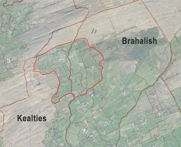
In the Tithe Applotment Books there is mention of two areas in the parish of Durrus called Eskanbreena and Esknabruna. You can see a list of townlands from the Tithe Applotment Books here. They are likely the same place and the surname “Corty” listed is likely “Carty” from McCarthy. There is mention of Esknabreena as being in North West Brahalish (source). However, currently there is no local knowledge of the name.
Link to the Tithe Applotment Books Eskanbreena
Link to the Tithe Applotment Books Eskanbruna
This area is listed as separate from Kealties and Brahalish at the time of the Tithe Applotment records (1830), but by 1850 when the OSI conduct what is known as the Griffith evaluation map there is no record of Esknabreena.
There are a lot of Irish placenames that begin with the ‘Esk-na’ part: https://www.logainm.ie/en/s?txt=Eisc+na&str=on. “Eisc” usually refer to a stream/river/water, and one translation is “track of a stream or mountain torrent” (https://www.logainm.ie/en/8486). There is a large stream that runs the border between Brahalish and Kealties. In the summer it is a steady stream but in the winter it can be raging with water.
Irish placenames often describe the geography of the area they name. Very prominent features in Brahalish are the ringforts. So one possible original Irish form of the name could be Eisc na Bruíne (also Eisc na Bruíghne), where Bruíghne can mean ringforts/fairy dwelling or strife. This would translate roughly as “place of the mountain stream of the ringforts”.
Another possibility is a word associated with boggy ground, as the North West of Brahalish has very wet areas. For example, bhréanaidh – https://www.logainm.ie/en/33065 (“a fetid place, a slow-flowing stream which consequently becomes fetid”).
In Éamon Lankford’s fieldnames collection, there is mention of “Ros na Bruighne” in Kealties but the location is unknown. “Ros” can mean headland or wooded area, and the meaning given by Éamon Lankford is ‘headland of strife’. There is only one area in Kealties and one area in Brahalish that could be described as a headland. However, there could be many places that were once wooded, the sides and valleys of the ringforts for example.

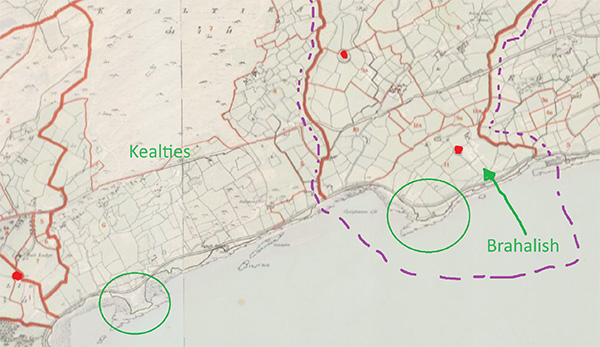
The oldest maps with details of the area are the from the Down Survey (1656-1658). They are not very accurate, but they do highlight areas in the North West of Brahalish that could be locations for Esknabreena.
The Griffith evaluation map is shown in the top row, with the Down survey extracts below it. The top right image has the Griffith map and the Down Survey superimposed over each other. In the second row, the first image is from the Down Survey overview and the second image is the more detailed map from the parish maps. The third image highlights on the Griffith map the lightly path of the divisions from the Down map. The areas enclosed in purple are likely Esknabreena. The boundaries don't line up very well, especially with the borders with Gerahies. However, the circular feature in the blue boundary of the middle image is very likely Cummer Fort.
