Frequently Asked Questions – Interactive Map
The features available in the interactive maps are highlighted below and explained.


Left Menu – This menu contains different interactive buttons that allow you to zoom, go full screen, read GPS coordinates, show your location, search and go to this FAQ.
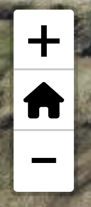
This button allows you to zoom in (+) and zoom out (-). The house symbol will take you back to the default zoom and location.

This button allows puts the map in full screen, and takes you out of full screen.
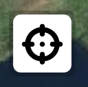
Once clicked, this button gives the GPS coordinates of the crosshairs that appears in the center of the map.

This button will find your current location. This will work well on any GPS enabled smart phone with location enabled for your browser, but may not work on Desktop well.

This button opens a search bar, where you can search the layers from the right menu, e.g. heritage sites, townlands, etc.

This button opens a window to this FAQ page.

Top and right side distance rulers – The top and right side of the map have graduations that change depending on the scale of the map. These can be used to estimate distances.

Backing maps and features – This menu allows you to change the backing map and add or remove various features.
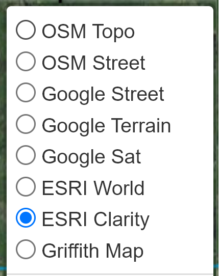
Clicking the circles activates the corresponding map. There are 3 map providers and a historic map.
OSM: Open Street Map topology and street map version.
Google: Google street and terrain versions.
ESRI: Environmental Systems Research Institute satellite maps, “Clarity” is clearer but older than “World”.
Griffith Map: This is the Griffith evaluation map of c.1850.

Clicking the circles activates the corresponding features.
SHW West: This is the Sheep’s Head Way West trail.
SHW East: This is the Sheep’s Head Way East trail.
SHW West Loops: Loop walks in the Western Sheep’s Head Way.
SHW East Loops: Loop walks in the Eastern Sheep’s Head Way.
Heritage Sites: Heritage sites along the walks.
Shoreline Names: names of coastal features along Sheep’s Head.
Parking: Parking sites along the walk.
Seating: Seating along the walks.
Harbours: Significant harbours along the Sheep’s Head Peninsula.
Churches: Churches along the walks.
Townlands: Townlands are shown with links to their names, meanings and other resources.
Parishes: Parishes are shown with links to their names, meanings and other resources.
Irish OSI grid: The Irish grid reference system is overlayed.

Map Slider

This slider allows you to slide between the current chosen map and the previously chosen map. You can then see the difference between the 1850 Griffith’s map and a current satellite image, for example.

Map Resizer

Dragging this icon allows you to resize the map when not in full screen. This can be useful on mobile devices.